


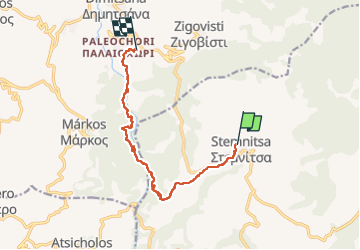
Gorges de la Louisios

Jerome.mychalski
User

Length
12.5 km

Max alt
1129 m

Uphill gradient
699 m
Km-Effort
23 km

Min alt
428 m

Downhill gradient
955 m
Boucle
No
Creation date :
2025-05-27 07:20:12.811
Updated on :
2025-05-27 12:54:46.911
3h47
Difficulty : Medium

FREE GPS app for hiking
 SityTrail
IGN / Geographical institutes
SityTrail Plus
The world is yours!
About
Trail Walking of 12.5 km to be discovered at Peloponnese, Western Greece and the Ionian, Arcadia Regional Unit, Municipal Unit of Trikolonoi. This trail is proposed by Jerome.mychalski.
Description
Randonnée dans les gorges de la Louisios
Positioning
Country:
Greece
Region :
Peloponnese, Western Greece and the Ionian
Department/Province :
Arcadia Regional Unit
Municipality :
Municipal Unit of Trikolonoi
Location:
Unknown
Start:(Dec)
Start:(UTM)
595568 ; 4157249 (34S) N.
Comments